History
Pre-Newtonmore (the Townships)
In Pictland, the river would often give its name, or that of a feature of it, to the glen or part of it, through which it ran.
Glen Banchor, therefore, is named after the long bend in the river at the Luib, above the village – A Beannachar is a horn-shaped reach of a river bank and was a favourite place for siting a monastic cell, or monastery. There was a chapel in Glen Banchor dedicated to St Bridget of Kildare (gaelicised as Cladh Bride), whose saint’s day is 12th February. There was a long standing convention that there would be no grinding at the mill on that day. The present church in Newtonmore, built in 1960, is also called St. Bride’s.
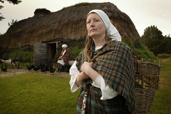
An example of a turf built black house – this one can be seen in the Highland Folk Museum
In historic times, the population in rural areas tended to be gathered in Townships, small collections of rough houses built of stones, turf and timber round which the occupants leased small crofts from the local estate. Superb reconstructions of these buildings can be seen at the Highland Folk Museum, where replicas have been built using only the tools that were used at the time.
In 1841 there were eight townships in Glen Banchor, the ruins of which can still be seen marked on OS maps – Easterton, Westerton, Dalvalloch, Dalchurn, Lurgan, Milton, Croft Couneach, and Luib.
The estate records of 1841 showed 21 houses in the townships with 85 inhabitants. This fell, mainly due to clearances, till in 1891 there were just three houses occupied, with 12 inhabitants. Though the bulk of the clearances occurred between 1851 and 1891, the first clearances to make way for sheep were from Baillidbeg as early as 1760. The ruins of the houses can still be seen on the north bank of the River Spey just across from the Haflinger Pony-trekking Centre.
Up in the hills to the north of the River Calder, the summer sheilings can be seen (marked on OS maps). From May 1st to November 11th, the sheep and cattle were moved up the hill to summer grazing, returning in the winter to graze on the common land of the crofts (leading to the common township name to be found in many areas of the highlands of ‘Winterton’). The families moved with the livestock and the ruins of the buildings can still be seen near the Red Bothy.