In addition to the sites listed on the Newtonmore Heritage Trail leaflet, there are many other points of interest throughout the village which are well worth a look…
A. Broom Lea
One of the two oldest houses in the village, local tradition has it that this was the home of the ferryman who brought travellers over the Spey.
The building, which has been altered greatly over the years, also provided stabling for coach horses.
Sources
Local residents
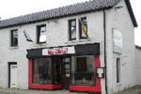
B. Letterbox Restaurant
This is the site of the original village post office. It used to be known as Dod’s Corner after George Macpherson, who had a café on the site and a shop where he made shinty and golf clubs.
Boys used to gather outside on a Saturday afternoon waiting for the shinty results to come through.
Sources
Local residents
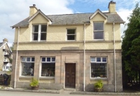
C. Bank House
One of two original banks in the village, the British Linen Bank first opened a branch in Newtonmore in 1906 then moved to this location in 1934.
This building was used as the lawyer’s office in Monarch of the Glen.
Sources
Kingussie Record Local residents
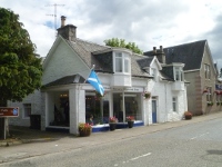
D. Oldest Shop
Originally opened in the late 1800s as a coal merchant, this is now the oldest continuous business premises in the village.
The building has previously housed an antique shop and a book shop.
Sources
Local residents
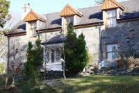
E. Bell Cottage
This was the home of Rear Admiral John Yendell who was present at the Japanese surrender ceremony aboard the United States Navy battleship USS Missouri on 2 September 1945.
The cottage got its name from a ship’s bell which Admiral Yendell brought home and which hung outside the cottage for many years.
Sources
Local residents
F. Speyville
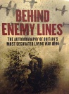
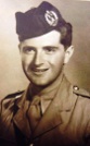
This is the home of Sir Thomas Macpherson, the most decorated soldier in the British Army and the grandson of a Newtonmore crofter. Sir Tommy’s many war exploits are described in his autobiography Behind Enemy Lines (2010).
SirTommyHis operations with the French resistance were so successful that the Germans described him as “A bandit masquerading as a Scottish officer” and put a bounty on his head. His most famous action was bluffing 23,000 German troops who were advancing on the Normandy beach-head to surrender after he arrived at their headquarters accompanied only by a doctor and French officer. Sir Tommy’s many decorations include the Military Cross, the Croix de Guerre and a papal knighthood
Sources
Macpherson, T. (2010) Behind Enemy Lines
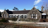
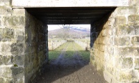
G. Railway Station
The opening of the Inverness and Perth Junction Railway in 1863 revolutionised life in Badenoch.
The area had to a great extent been cut off from outside influences due to the surrounding mountains. The economy of the whole district developed rapidly in the later 19th century as trains brought in tourists, attracted by the magnificent scenery and fresh mountain air.
By the 1890s Newtonmore was a fashionable holiday resort and in 1903 the local paper reported: the Badenoch district, being formerly isolated, owes more to the promoters of the railway than any district in the north. The building of the line was the making of Kingussie, Newtonmore and other stations, which have become favourite health resorts, and are becoming more popular every year.
In April 1893 the original wooden station buildings were destroyed in a fire started by a spark from the grate in the office. Despite the best efforts of station staff and villagers who rushed to help, the buildings were reduced to ashes. They were replaced by this stone building. The architect was William Roberts, who also designed Aviemore, Kingussie and Boat of Garten stations. In 1907 a new road from the station to the village was opened.
Two fatal accidents have occurred at Newtonmore Station. In August 1894 John Dobie, Professor of Hebrew at Edinburgh University was killed when a passenger train from Perth collided with a goods train. He was attending to his horse in the horse box when the trains collided. In September 1900, a brakesman, James Ormiston, was killed in a shunting accident at the station.
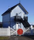
The station won many awards under the care of a former station master Jock Paul Macintosh, who was also a noted shinty player. He kept the stations gardens in good trim and always had a fire burning in the waiting room. The building which looks like a signal box was built in 2004 as self-catering accommodation.
Sources
Local residents Dundee Courier Glasgow Herald Kingussie Record Dictionary of Scottish Architects: read more Railways Archive: read more
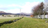
H. Old Coffin Road
Funerals from the townships of Nuide and Phones on the south side of the Spey crossed the river by a ferry at Ralia and went straight across the fields to Banchor Cemetery.
The coffin road can be seen running from the Spey under the railway.
It crosses the road and continues through the field beside the Newtonmore Grill, then crosses the Laggan Road to reach Banchor Cemetery (see no.13).
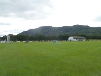
This is the famous Eilan, home of Newtonmore Camanachd Club. Camanachd or shinty, the ancient game of the Highlanders, has been played here since time immemorial.
Eilan comes from the Gaelic word for island: this area originally lay between two branches of the river Calder.
Shinty plays a very important role in the life of local communities. Newtonmore is one of the most successful shinty clubs in Scotland. They have won the national championship, the Camanachd Cup, on thirty occasions, starting in 1907.
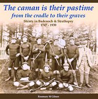
A history of shinty in the area has recently been published: The Caman is Their Pastime from the Cradle to their Graves: Shinty in Badenoch and Strathspey 1747-1939 by Rosemary M Gibson. It is available from local shops and the Newtonmore Camanachd Club website http://www.newtonmoreshinty.com/ on which you will also find more information on shinty and a fixture list.
You can see shinty games here on most Saturday afternoons from March to October. The Eilan is also the venue for the Newtonmore Highland Games, held on the first Saturday in August.
The original bridge over the Spey was open by 1765. It was built by John Scott, master mason, at a cost of £1,500.
The bridge was part of the re-routing of Wade’s military road from Etteridge to Ruthven carried out by his successor Major Caulfeild.
The bridging of the Spey had far-reaching effects in the area. The new crossing diverted travellers from the south side of the river and in bypassing the ferry at Ruthven it marked the beginning of the end for that burgh. The diversion of the main highway to the north side of the Spey led to the establishment of the inn at Pitmain, the founding of Kingussie at the end of the 18th century and of Newtonmore in the early 19th century.
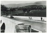
By the 1920s the original bridge was in a poor state and was too narrow for the volume of traffic. It was replaced by this bridge in 1927 as part of the reconstruction of the Great North Road, now the A9. The rebuilding of the road was a huge construction project which provided much-needed employment: at one point some 1,500 men were working on the road. Seventy eight miles of road between Blair Atholl and Inverness were rebuilt between 1925 and 1928, at a cost of £654,476, or £8,390 per mile.
Spey Bridge was one of the largest of the sixty bridges involved in the project. It cost £23,363. The bridge was designed by the architect Maxwell Ayrton and the engineer Sir Owen Williams and built by Sir Robert MacAlpine and sons. Its three spans measure 67ft (20.4m), 87ft ( 26.5m) and 107ft (32.6m). It is built of reinforced concrete.
Sources
George Dixon Local residents Badenoch Record Bruce, R. (1931) “The Great North Road over the Grampians”, Proceedings of the Institute of Civil Engineers, 232: 113-154. Royal Commission on the Ancient and Historical Monuments of Scotland: read more
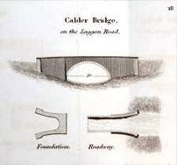
K. Calder Bridge
The original Calder Bridge was designed by Thomas Telford for the Commissioners for Highland Roads and Bridges as part of the new road from Kingussie to Fort William which opened in 1818.
It was partly funded by local landowners – the Duke of Gordon, Mackintosh of Mackintosh and Cluny Macpherson – and opened in 1814. The Telford bridge was an arch 32 feet (9.8m) tall with a span of 50 feet (15.2m).
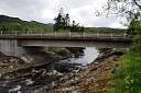
After standing for more than 160 years, part of the old bridge was washed away when the River Calder was in flood on 15 November 1978. Local resident Rob Ritchie crossed the bridge shortly before and heard boulders being washed down the river in the floodwater. The damage was such that the rest of the A-listed bridge had to be demolished. It is a tribute to its builders that it took three explosions to bring down the bridge. What little remains of the old bridge can be seen upstream.
A temporary Bailey bridge was used until the present bridge opened in 1982. It was designed by Highland Regional Council’s Department of Roads and Transport.
Sources
George Dixon Local residents T. Ruddock (1979) Arch Bridges and their Builders 1735-1835. Royal Commission on the Ancient and Historical Monuments of Scotland: read more Strathspey and Badenoch Herald
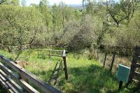
L. Well of the Alder
This spring has been used for centuries. Its Gaelic name – Fuaran lag an dromain – means the spring of the hollow of the ridge.
It has always been popular: local residents drew water here long after the village had a piped water supply. Some believed the well had healing properties: at least one resident requested water from the spring on his deathbed. The water was reckoned to be particularly good with whisky.
The Newtonmore Community Woodland & Development Trust recently refurbished the site and put up an interpretive panel on which you will find further information.
Sources
Newtonmore Community Woodland & Development Trust Local residents